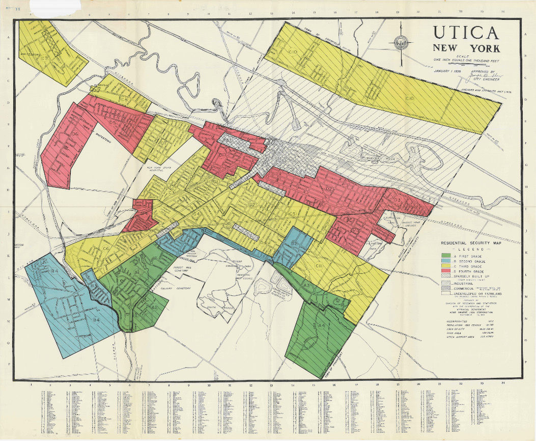
top of page

Utica

REDLINING


The Home Owners Loan Corporation, a Depression-era Federal government agency, created residential security maps for cities across the country between the years 1935 and 1940.  These maps were intended to advise mortgage lenders regarding risk in writing mortgages in specific areas based upon a variety of criteria, including the presence of Black and immigrant residents.  Local consultants were often hired by the agency to gather data ("area descriptions") for those maps.


Eight prominent local men collaborated with the HOLC field agent in preparing the 26 area descriptions for Utica, NY, and the neighboring municipalities of New Hartford, Yorkville, and Whitesboro .  They included:


1) Edward Conboy, a fee appraiser for the HOLC and a real estate broker with 35 years experience in Utica;

2) Graham Coventry, who was responsible for real estate and mortgages as Vice President of First Citizens Bank & Trust Co., Utica’s largest bank and one which was heavily involved in real estate;

3) Ralph Davies, Treasure of the Homestead Aid Association, the second largest holder of mortgages in Utica;  

4) Joseph Matt, member of Utica’s Board of Assessors who had previously been an HOLC appraiser as well as a real estate broker; 5) Elmer J. Meloche; a real estate and insurance broker in Binghamton, NY, who had previously served as chief appraiser for the HOLC, then chief appraiser of the HOLC’s central New York district ;

6) Clarence J. Mercy, Vice President of and HOLC Contract Management Broker for Hugh R. Jones, Inc., the most prolific developer of subdivisions in Utica over the previous 20 years;

7) Roy C. Van Denberg, President of the Utica Savings Bank, the largest holder of residential mortgages in Utica, where he “[personally supervised]… the bank’s mortgage portfolio and real estate account” ; and  

8) John D. White, former vice president of the National Association of real Estate Boards , former president of the New York State Association of Realty Boards , member of the Survey Committee of the Utica Real Estate Board, and an active, longtime real estate broker.  


Meloche, Matt, White, and VanDenberg also further served as consultants in the preparation of accompanying residential security map for Utica and its three adjacent suburbs .


Two of the four areas designated on the residential security map as first grade (green) were in the Town of New Hartford, including area A-2 which notably contained the Benton Hills subdivision.  William A. Benton, President of Benton Hills Realty Corporation, began developing the subdivision in 1938 on the former Maple Hill Farm, a 200-acre property he’d inherited from his father .


According to the corresponding area description, $10 million had been invested in the past year in the subdivision which contained five single-family homes with wooden frames and either stone or brick veneers, all of which were owner-occupied.  Only 10% of the area had been developed and it was estimated at the time that there was another $9 million in demand in the area.  The availability of mortgage funds for buying or building a home was “good .”


One criterion used by HOLC to grade areas positively was the use of “restrictions set up to protect the neighborhood .” In July of 1940, Benton signed and submitted a declaration of restrictions for the subdivision that included the following racial restrictive covenant:  “No person of any race other than the Caucasian race shall use or occupy any building on any lot, except that this covenant shall not prevent occupancy by domestic servants of a different race domiciled with an owner or tenant .”  


According to the area description, there were no foreign-born, negro, or “Relief families” in the area; residents’ occupations were characterized as “business and professional” and the estimated annual family income was between $5000 and $20,000.  Among the area’s advantages were, “very low taxes and good transportation, schools, etc.


The map designated six areas as fourth grade (red).  Notable among the redlined areas were D-1, “Central Utica,” which was home to Polish American laborers and “all of Utica’s small Negro population [which was] concentrated in this area along the railroad tracks .”  Nearly all of Utica’s black residents had only just relocated to that area of the city by 1912 ⑬.  In 1890, 163 out of Utica’s 244 black residents lived in a small ghetto on Post Street  between Charlotte and Burnett streets.  Charles Kilkenny and James J. Dwyer purchased all of the lots on Post Street around 1899 and promptly began to tear down every building, evicting 22 families .  In 1918, it was reported that the last of the neighborhood’s black residents had been evicted from the second floor of 219 Post Street, vividly described as a, “dilapidated old house… [with] the windows in the cellar and first floor being broken or out entirely gone ” and which was slated for demolition.


A slum developed in area D-1between Seneca and Hoyt Streets, "occupied largely by colored people, who had been forced to live in the most unsanitary surroundings ," and many families in were on relief. This area was adjacent to industrial sites and the city’s business center and the HOLC gave it a grade of “D -.”  It was estimated that there was 95% occupancy of the one- and two-family houses, the average age of which was approximately 35 years.  Homes were considered to be in “fair to poor” repair and no new construction had taken place in the past year.  Only 40% of residents were homeowners, sale of real estate had been “nominal,” and there were no mortgage funds available for either buying or building a home.


Area D-2, “East Utica,” had the largest concentration of Utica’s Italian and Italian American population, consisting mostly of laborers and local shopkeepers.  As in area D-1, many families were on relief.  Approximately 70% of the 35,000 residents of the area were of Italian descent, 35% of whom were foreign-born.  The frame and brick homes were in poor repair, averaging 35 years old, and 40% had been converted into two-family homes.  Some homes were a combination of store and dwelling, and a few buildings contained three or four units.  50% of residents were homeowners and occupancy was estimated at 94%.  No homes had been constructed in the past year, and both real estate activity and the availability of mortgage funds were described as “very poor ⑱.”  Adjacent area D-3 was also part of the city’s predominantly Italian East side, where half of the residents in this “sparsely settled area; much of which is given over to truck gardens with small shacks ,” were foreign-born.  Homeownership was estimated at 60% and homes were in poor repair.  Only 15% of the land had been developed, no new construction and nominal real estate activity was noted, and no mortgage funds were available in this area.


SEYMOUR GARDENS

​The Home Realty & Development Company developed Seymour Gardens in 1933.  The subdivision included 176 lots on Riverside, Hughes, Spruce, Cypress, Tamarick, and Horatio Streets, and Lorraine Avenue.    The following spring, an ad in the Observer Dispatch newspaper promised potential homebuyers "good clean country air" in "a healthful location" that was "well restricted, [with] no shacks of any kind permitted ⑳."

Deeds in the subdivision contained the following Whites-only racial covenant:


 Division of Research and Statistics, Home Loan Bank Board (1938, 19 September). “Utica - New York, including New Hartford, Yorkville and Whitesboro,” [report], Section I, p. 2. NATIONAL ARCHIVES CITATION?

 “Meloche Dies; Ex-Assessor;, FHA official.”  Press and Sun-Bulletin (Binghamton, NY) Dec 1, 1963, Page 41. Accessed via newspapers.com

 Division of Research and Statistics, Home Loan Bank Board, (Ibid.), Section I, p. 3.

 National Association of Real Estate Boards (1925, 22 June). “Minutes of Board of Directors Meeting. Accessed at https://repository.nar.realtor/server/api/core/bitstreams/b6de87cc-ac90-4f00-ad80-86c375f53da7/content

 The Record and Guide Company (1920, 6 November). “Review of Real Estate Market for the Current Week,” Real Estate Record and Builders Guide, vol. 106 no.19, p. 641. Accessed at https://rerecord.library.columbia.edu/pdf_files/ ldpd_7031148_066_45.pdf

 Division of Research and Statistics, Home Loan Bank Board, (Ibid.), Section II, p. 27.

 “People Worth Knowing.” Utica Observer-Dispatch (Utica. NY), 20 December, 19XX, p. Accessed via fultonhistory.com

 Division of Research and Statistics, Home Loan Bank Board, (Ibid.), Section II, p. 3

 Ibid., Section I, p. 1.

 “Declaration of Restrictions,” 31 July 1940, Benton Hills Realty Corporation (Deed Book 997, page 495, Records Department of the Office of the Oneida County Clerk, Oneida County, NY).

 Division of Research and Statistics, Home Loan Bank Board, (Ibid.), Section II, p. 3.

 Ibid, Section II, p. 21.

 “The Negro settlement on Post Street will soon be only a memory: Most of its carefree denizens have migrated to the Second Ward,” Utica Sunday Tribune (Utica, NY), 1 December 1912. Accessed at http://godontheground.blogspot.com/2014/ 03/elizabeth-street-iii.html

“Timeline for Blacks in Oneida County,” Anonymous (undated), Oneida County Black History Archive, Burke Library, Hamilton College Archival Collections, Cassandra Harris Lockwood Papers.

“Passing of Post Ave,” Utica Sunday Journal (Utica, NY), 28 July 1899. Accessed via fultonhistory.com

“No more colored folks on Post St: Only remaining dwelling on once noted Avenue to be demolished -- permit issues to-day [sic],” Utica Observer Dispatch (Utica, NY), 12 June 1918. Accessed via fultonhistory.com

⑰ Clarke, T. Wood. (1952). Utica for a century and a half. Utica, p. 164. NY: The Widtman Press.  Quoted in Ownes-Manley (2009) 

⑱ Division of Research and Statistics, Home Loan Bank Board, (Ibid.), Section II, p. 22.

⑲ Division of Research and Statistics, Home Loan Bank Board, (Ibid.), Section II, p. 23.

⑳ Utica Observer-Dispatch, May 6, 1934, 4-,B  Accessed via fultonhistory.com

© MAY 2026

Utica_redlining_map_rescaled.jpg
1938 HOLC Residential security map of Utica, NY.  SOURCE:  Mapping Inequality, https://dsl.richmond.edu
“Benton Hills Map of lots on Higby Road, Tilton Road, Westminster Road, Windsor Terrace, Bradley Road and Old Orchard Road, in the town of New Hartford, N.Y.”  SOURCE: Map Book 9, page 10, Map Room of the Office of the Oneida County Clerk, Oneida County, NY.
1938 HOLC Area description of Utica, NY, (D-1).
“The Negro settlement on Post Street will soon be only a memory: Most of its carefree denizens have migrated to the Second Ward,” Utica Sunday Tribue, (Utica, NY) 1 December 1912.  SOURCE:  “Around Town, Utica, NY” [http://godontheground.blogspot.com/2014/03/elizabeth-street-iii.html]
A4.jpg
1938 HOLC Area description of Utica, NY, (A-4).  SOURCE:
D1.jpg
D3.jpg
D2.jpg
1938 HOLC Area descriptions of Utica, NY, (D-2, D-3).
IMG_1357.jpeg
IMG_1358.jpeg
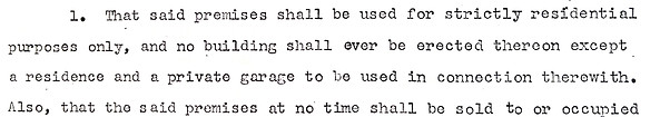
EXCERPT: Deed, 19 October 1954, Deed Book 1454, pages 455-8, Office of the Oneida County Clerk, Oneida County, NY.

© 2035 by Urban Artist. Powered and secured by Wix

bottom of page